Northern Isaan trip

Dodraugen

0
Subscribed
Aug 19, 2012
391
298
63
57
Lampang
Gday everybody, hope youre all doing fine.

I had my yearly stay in Thailand from 1th of January to 16th of February and in that period of time I did approx 7000 kms on my trusty Mianoi aka the Crf250L. I thought I could try to contribute a bit to this forum by writing a tripreport that might be of interest to other riders.

I did 3 longer trips, all with my wife riding as a pillion. The first trip was to Mae Hong Son - but thats a trip everybody in here including me have done many times already so no point making a trip report about that. Also we rode south to Prachuap Khiri Kan which was indeed a nice place with plenty of interesting stuff to see - spent 4 days in the provincial capital with the same name and 2 days in Kuiburi. But the ride down south from our base in Lampang is dull and boring to say the least - so I wont talk about that.

But we did an interesting trip to northern Isaan and visited Chiang Khan, Bueng Kan (stayed in Bung Khla) Kumphawapi (Udon Thani) and Roi Et and also had a night in Chum Phae on the way back. So it was a 7 nights/8 days trip.

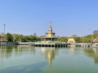
We took of from Lampang quite early and rode the R11 and had our first stop at this rest stop:

A great place for coffee, food and a toilet break. Several small restaurants and coffeeshops. Also the views are great and prices reasonably. Only approx 20 kms south of the Den Chai junction on the R11. Its called Khao Plung rest stop.
Highly recommended!

IMG_7991.jpeg
IMG_7990.jpeg
IMG_7989.jpeg


We rode further and took the «shortcut» between the north and northeast via R1143 to Nakhon Thai. Its not the most interesting ride but still better than down to the plains of R11 and R12 - and its shorter.

We had a quick lunch in Chat Trakan and met a thai guy from Bangkok on his Honda Cub. I find it so great that thais travel on small bikes, its shows that one can travel long distance and enjoy the trip just as much on a small bike….
IMG_7994.jpeg
IMG_7995.jpeg


To be continued….
 
Last edited:

Dodraugen

0
Subscribed
Aug 19, 2012
391
298
63
57
Lampang
From Nakhon Thai we continued towards Chiang Khan on R2013, then R21 and then deviated a bit from the main route by taking R2399 and rural rd4014 towards the Mekong rd R2195. Quite some spectacular ride over the mountains there - unfortunately I didnt stop for photos.
We came down to the Mekong at where the Chiang Khan skywalk is as we wanted to see it. Unfortunately we were too late (at 5.30 pm) and they had already closed. Well - better luck next time we thought and continued towards Chiang Khan which is approx 20 kms further east along the R2195.

We hadnt booked any accomodation at Chiang Khan but soon found an ok place to stay for the night.
We stayed at this place:

Chiang Khan Huen Hak

I am sorry I didnt take any pics as I wasnt thinking about making a trip report at that stage. But it was an ok place to spend a night, its on the upper side of the main road through CK so a bit away from the hustle and bustle of the walking street. But still only a 10 minute walk to the walking street.

The price was 600 baht a night and the owner was friendly. The room had all the amenities I would like as a fridge, hot shower, aircon and a western toilet. Safe parking behind a gate and coffe/tea for breakfast.
Would I stay there again? Yes why not.

So after a quick shower we headed down to the walking street area. Its really a nice walking steet market there, of course a bit touristy but very few farangs to be seen. Many lovely old wooden houses too….
A few pics from Chiang Khan walking street area…
IMG_8008.jpeg


IMG_8015.jpeg


IMG_7998.jpeg


IMG_7999.jpeg


IMG_8016.jpeg


IMG_8025.jpeg


IMG_8032.jpeg


IMG_8035.jpeg


To be continued….
 
  • Like
Reactions: Wayne66

Dodraugen

0
Subscribed
Aug 19, 2012
391
298
63
57
Lampang
The next morning we went down to the walking street area again for a few pics and a brew and then started to ride towards Bueng Kan as was our goal for the day.

The first stop were at Sangkhom and the Skywalk at Wat Pha Tak Seua. I had been there before but wifey hadnt and since we missed the skywalk in Chiang Khan this was the opportunity to see a skywalk for her.

But luck wasnt on our side this day either as the Sangkhom skywalk was closed for upgrades!
Anyhow - we had stopped already and ridden the detour (which is quite a few kms) so we decided to have a cold drink and walk around a bit at the Wat. They are expanding the temple area hugely now - I guess they have made some money on the Skywalk….

A few pics from Wat Pha Tak Seua (Sangkhom Skywalk)
IMG_8039.jpeg


IMG_8038.jpeg


IMG_8049.jpeg
IMG_8041.jpeg


We continued onwards and had lunch in Nong Khai at one of the farang bar/restaurants along the riverside.


IMG_8056.jpeg


IMG_8054.jpeg


IMG_8051.jpeg


And then we rode the last leg towards towards Bueng Kan.

I had read somewhere that Bueng Kan wasnt the most lively town and that Bung Khla a further 50 kms down the Mekong was a better place to stay while exploring the province - so we headed there.

I had seen a bungalow resort there that looked like a bargain so we went there and asked if they had any vacancies. And sure they had! Riverfront aircon bunglows for 600 baht, also they had rooms on the other side of the road for 350 and 500 baht. I guess the 350s were without aircon.
The place is called Mon Prasit.
We stayed there for 2 nights and would highly recommend this place. Wooden bungalows with big bathrooms with all the ameneties one would want - at only 600 baht for a riverfront location.

Again - I didnt plan to make a trip report so didnt take much photos of the place.


IMG_8166.jpeg


View from the bungalow:
IMG_8058.jpeg


There arent much going on in Bung Khla at daytime but it was a wonderful place to spend the nights while we checked out POI in Bueng Kan province.

They are building a new riverfront walk in Bung Khla and it will probably be a great feature of this little Isaan town. There are other accomodations possibilities there too just to mention.

For food there were several options. We choose this one:
Riverview Kitchen restaurant Bung Khla. And I have to say it was some of the best thai food I have ever eaten. And my thai wife agreed! And she is a cook by profession - so that says a bit!
Portions were huge, prices a bit on the dearer side but well worth it.

IMG_8057.jpeg


To be continued
 
Last edited:
  • Like
Reactions: Wayne66

Dodraugen

0
Subscribed
Aug 19, 2012
391
298
63
57
Lampang
Woke up to a misty Mekong morning - but the mist soon disappeared. We set off to our first goal of the day which was the Hin Sam Wan or in english - The Three Whale Rock.
Its a peculiar rock formation - at the top of a ridge of steep cliffs that somewht resembles 3 huge whales. If seen from above I guess its quite spectacular but a little less spectacular directly nearby.

Wikipedia on Three Whale Rock/Hin Sam Wan


We were told this place were given the title of a Thai National Park a year ago or so, so its now mandatory with a pick-up truck with driver to take one to the top and stop along all the other sights along the road. Because its not only the 3 whale rocks that are POI there, there are several peculiar stone formations and caves along the way. The price for a pick-up with driver was 500 baht and he could take up to 6 persons I think. At the entrance to the National Park there are of course several restaurants and coffeeshops, toilet facilities etc. Not bad as the National Park status was only 1 year old.

Some pics from the 3 whale rock national park:
IMG_8096.jpeg

This is how the 3 «whales» look from above. Mama whale, Papa whale and kid whale….


IMG_8084.jpeg


IMG_8089.jpeg


IMG_8070.jpeg


IMG_8093.jpeg


IMG_8068.jpeg


IMG_8102.jpeg


IMG_8104.jpeg

One can take some really cool photos on the top of the 3 whale rocks…

Some pics of some of the other attractions in Three Whale Rock National Park:
IMG_8060.jpeg


IMG_8105.jpeg


IMG_8113.jpeg


IMG_8117.jpeg


View from the top of Three Whale Rock
IMG_8073.jpeg


Strangely - some of the pics wouldnt upload to forum because they were too big?

Anyhow - the trip to Three Whale Rock was great. It takes 2-3 hours up there and of course the trip to the entrance, so all in all a half day trip easily.

IMG_8095.jpeg


IMG_8081.jpeg


IMG_8091.jpeg
 
Last edited:
  • Like
Reactions: Gregthemagnificent

Dodraugen

0
Subscribed
Aug 19, 2012
391
298
63
57
Lampang
The next place we chose to check out in Bung Kan province was Wat Phu Tok. A temple complex build in/on/around a huge steep cliff. Its situated around 50 kms south of Three Whale rock.


Wat Phu Tok on Lonely Planet: Wat Phu Thok | Northeastern Thailand, Thailand | Attractions - Lonely Planet

Its quite a physical challenge as one needs to climb 2-300 meters in altitude, many ladders and staircases and paths which werent all to western standards. Its seven «layers» to get to the top!
Bring lots of water and leave your fear of hights behind before you start the climb!

Some photos from Wat Phu Tok with comments below the pics.

IMG_8120.jpeg

The Cliff temple of Wat Phu Tok seen from below…

IMG_8118.jpeg

Wat Phu Tok in the background with a pagoda build down below.

IMG_8125.jpeg

Some rickety staicases…

IMG_8122.jpeg

One of the 7 levels of Wat Phu Tok

IMG_8123.jpeg

Munk statues….

IMG_8135.jpeg

The pagoda and temple complex at the base of Wat Phu Tok seen from above.

IMG_8147.jpeg

Steep cliffs at Wat Phu Tok

IMG_8132.jpeg

Another steep cliff seen from Wat Phu Tok
IMG_8143.jpeg

At Wat Phu Tok

IMG_8146.jpeg

Some really strange stone formations…

IMG_8164.jpeg

Wat Phu Tok from below

IMG_8159.jpeg

Pagoda at the base of Wat Phu Tok

IMG_8157.jpeg

Inside the pagoda…

IMG_8155.jpeg

Inside the pagoda

IMG_8156.jpeg

Inside the pagoda

It was a really interesting place and temple. And it gave us some great work out while climbing all the 7 levels….
One could easily spend a whole day at the cliff temple of Wat Phu Tok but we spent the second half of a day there after we first went to 3 whale rock.
 
  • Like
Reactions: Wayne66

Dodraugen

0
Subscribed
Aug 19, 2012
391
298
63
57
Lampang
The next day we headed off to check out another Bueng Kan attraction, namely the Naka Cave.

The place is situated in the southern part of Bueng Kan, only a few kms from Nakhon Phanom province some 16 kms «inland» from R212 - the main road along the Mekong.
Naka Cave on Google maps:

I found some great info about the Naka Cave online here:

«Naka Cave, or Naga Cave, is one of the many wonders in Thailand. Often described as the ‘Snake Cave of Thailand’, Naka Cave owes its name to its snake-like rocks and formations. Because of its unique structure, there are many myths surrounding its history and how the cave came to be. Interestingly, the Naga (and Nagi) are serpent-like mythical creatures significant in several Southasian and Southeast Asian cultures. Moreover, this is also a place of religious significance. In the past several years, Naka Cave has become a major magnet for tourists.
https://getbybus.com/en/blog/visit-naka-cave/#Where_to_stay_around_Naka_Cave
There are many stories surrounding the Naka Cave, and many more questions the people not yet familiar with it ask. Naturally, many people wonder if the cave is a work of man’s hands. Others wonder if the cave is real at all, and some even claim that the photos of the location are fake. Well, the good news is that the cave is indeed very real, and it is a magnificent work of Mother Nature.
Although scientists are yet to definitely conclude what exactly influenced its appearance, they have debunked one popular theory. Many people believed that the snake rocks of the Naka Cave are remains of a fossilized or petrified giant serpent. However, that story is just a myth, and the scientists have determined what caused the cave’s appearance. You can learn more about it in the text below.

You can find the cave within the borders of the Phu Langka National Park in Bueng Kan Province. The park is on the northeastern border of Thailand, and can also be accessed from Laos. Moreover, the national park is a 10-hour car drive from Bangkok»

So another day with climbing a mountain, and the Naka Cave is a REAL workout. One need to have some physical strenght and have some endurance - and also wear some good footwear as its a rough climb! Also bring lots of water and some food/snacks.

As the cave is situated within Phu Langkha National Park so we had to pay a national park fee and a local guide is mandatory.
Its easily a full day trip if one wants to take in all sights along the way, allow at least a half day if you decide to check out the snake cave.

Some photos from Naka Cave

First some pics from the climb:
IMG_8169.jpeg


IMG_8181.jpeg


IMG_8186.jpeg


IMG_8177.jpeg


IMG_8278.jpeg


IMG_8189.jpeg

The climb is not for the faint hearted….

Pics of the «Naka» (snake)

IMG_8284.jpeg


IMG_8292.jpeg


IMG_8220.jpeg


IMG_8298.jpeg


IMG_8170.jpeg


IMG_8210.jpeg


IMG_8222.jpeg


Some pics from the top of the Naka Cave mountain:

IMG_8277.jpeg


IMG_8267.jpeg


IMG_8271.jpeg


IMG_8270.jpeg


IMG_8263.jpeg


IMG_8257.jpeg


IMG_8267.jpeg


A few other pics from Naka Cave:

IMG_8250.jpeg


IMG_8239.jpeg


IMG_8236.jpeg


IMG_8265.jpeg


IMG_8280.jpeg


IMG_8282.jpeg


Summary - again a very interesting place in Bueng Kan province with an interesting history.
If you decide to go there remember good footwear, some food/snacks, sunscreen etc.
You will need to pay a mandatory guide and a national park fee. They dont let people in after 2-3 pm.

There are of course restaurants, coffeshops and souvenirshops at the entrance of Naka Cave, and also several accomodation possibilities nearby.

To be continued…
 

Attachments

  • IMG_8268.jpeg
    IMG_8268.jpeg
    173.2 KB · Views: 4
  • Like
Reactions: Wayne66

DavidFL

0
Staff member
Subscribed
Jan 16, 2003
14,911
5,688
113
71
Chiang Khong
www.thegtrider.com
From Nakhon Thai we continued towards Chiang Khan on R2013, then R21 and then deviated a bit from the main route by taking R2399 and rural rd4014 towards the Mekong rd R2195. Quite some spectacular ride over the mountains there - unfortunately I didnt stop for photos.
We came down to the Mekong at where the Chiang Khan skywalk is as we wanted to see it. Unfortunately we were too late (at 5.30 pm) and they had already closed. Well - better luck next time we thought and continued towards Chiang Khan which is approx 20 kms further east along the R2195.

We hadnt booked any accomodation at Chiang Khan but soon found an ok place to stay for the night.
We stayed at this place:

Chiang Khan Huen Hak

I am sorry I didnt take any pics as I wasnt thinking about making a trip report at that stage. But it was an ok place to spend a night, its on the upper side of the main road through CK so a bit away from the hustle and bustle of the walking street. But still only a 10 minute walk to the walking street.

The price was 600 baht a night and the owner was friendly. The room had all the amenities I would like as a fridge, hot shower, aircon and a western toilet. Safe parking behind a gate and coffe/tea for breakfast.
Would I stay there again? Yes why not.

So after a quick shower we headed down to the walking street area. Its really a nice walking steet market there, of course a bit touristy but very few farangs to be seen. Many lovely old wooden houses too….
A few pics from Chiang Khan walking street area…View attachment 159023

View attachment 159024

View attachment 159026

View attachment 159025

View attachment 159027

View attachment 159028

View attachment 159029

View attachment 159030


To be continued….

I love the ride from Chat Trakarn - Nakhon Thai- Dan Sai.
I see you used the White House accommodation recommendation from Wayne66.
Did you consider any other places at all?
Because I still don't have a decent recommendation with off-street parking.
 

Dodraugen

0
Subscribed
Aug 19, 2012
391
298
63
57
Lampang
I love the ride from Chat Trakarn - Nakhon Thai- Dan Sai.
I see you used the White House accommodation recommendation from Wayne66.
Did you consider any other places at all?
Because I still don't have a decent recommendation with off-street parking.
Our choice of accomodation in Chiang Khan was totally random. I had set a waypoint on the GPS in the middle of town and from there we just took a random soi and started looking for accomodation and the place we ended up staying at - appeared….
 
  • Like
Reactions: DavidFL

Dodraugen

0
Subscribed
Aug 19, 2012
391
298
63
57
Lampang
So after Naka Cave we headed for Udon Thani province. Originally we had planned to have a look at some waterfalls in Bueng Kan but it was late January when we were there and we were told that all waterfalls were dry already at that stage - so towards Udon it was.
The place we had in mind to check out in the province of Udon Thani was the
Taley Bua Deng or in english The Red Lotus Sea.

The Red Lotus Sea on Lonely Planet:

So its a huge lake which name is Nong Han which in the right season (November to February) boasts an enormous amount of red/pink water lillies (not lotuses). Its quite a sight and is of course best experienced with a boat trip on the lake itself.

Nong Han lake is situated approx 40 kms southeast of Udon Thani city in the amphur of Kumphawapi.

On Google maps: à¹à¸à¸²à¸°à¸à¸à¸à¸«à¸¥à¸§à¸ à¸à¸°à¹à¸¥à¸à¸±à¸§à¹à¸à¸ · Kumphawapi District, Udon Thani

We had been at the 10 years ago but we were both late in the season and late in the day as we started from Udon in the morning. So we werent able to see the flowers back then.
This time we knew better. We booked a guest house very close to one of the boat piers that took tourists out on the lake.

We stayed at Bigboss homestay here:

An good place to stay for only 500 baht a night. The elderly couple who run that place were extremly friendly and helpful and helped us to find some food for dinner as we arrived waay after dark.

We had our alarm clock set at 5 am, had a very quick breakfast and rode down to the shores of Nong Han and after a bit of searching we found the boat pier and soon found a guy willing to take us out on the «Taley Bua Deng»
I think we payed 300 baht for the boat and tipped the guy another 2-300 hundred…

The boat pier: à¹à¸à¸²à¸°à¸à¸à¸à¸«à¸¥à¸§à¸ à¸à¸°à¹à¸¥à¸à¸±à¸§à¹à¸à¸ · Kumphawapi District, Udon Thani

Note that there are several boat piers around the lake where its possible to go out and have a look at the red watwr lillies. We randomly choose this one as it suited our route best. But it was all good fun. Not much english is spoken there though…

Some pics from the trip out on the Red Lotus

IMG_8328.jpeg


IMG_8310.jpeg


IMG_8347.jpeg


IMG_8354.jpeg
IMG_8352.jpeg


IMG_8370.jpeg


IMG_8371.jpeg


IMG_8384.jpeg


IMG_8386.jpeg


IMG_8394.jpeg


IMG_8400.jpeg


IMG_8438.jpeg


IMG_8435.jpeg


IMG_8384.jpeg


IMG_8409.jpeg


IMG_8387.jpeg


IMG_8438.jpeg


Sorry for the photo bombing, but as you can see and hopefully agree upon this place is quite a photogenic place LOL.

So the flowers here are not lotuses, they are water lillies. Most of them are red/pink but we saw a few whites too. Supposedly there should be some yellows too but we didnt spot any.

There are also a lot of birds as you can imagine out on the Nong Han lake. The birds are a bit shy of the noisy engines on the boats so difficult to get a decent photo with just a phone camera. But its an eldorado for bird spotters as well.

The boat trip took 2-2,5 hours and we were back at our accomodation at around 9 am.

All in all its a great sight - especially if you travel with a female companion…LOL

A few pics from our accomodation the Bigboss

IMG_8427.jpeg


IMG_8429.jpeg


IMG_8428.jpeg


IMG_8426.jpeg


IMG_8422.jpeg


We relaxed for a good hour before we started towards Roi Et which was our goal for the day….

To be continued….
 

Attachments

  • IMG_8407.jpeg
    IMG_8407.jpeg
    199.1 KB · Views: 0
  • IMG_8300.jpeg
    IMG_8300.jpeg
    176.1 KB · Views: 0
  • IMG_8301.jpeg
    IMG_8301.jpeg
    75.5 KB · Views: 0
  • IMG_8304.jpeg
    IMG_8304.jpeg
    83.2 KB · Views: 0
  • IMG_8307.jpeg
    IMG_8307.jpeg
    190.4 KB · Views: 0
  • IMG_8306.jpeg
    IMG_8306.jpeg
    136.3 KB · Views: 0
  • IMG_8314.jpeg
    IMG_8314.jpeg
    155.5 KB · Views: 0
  • IMG_8313.jpeg
    IMG_8313.jpeg
    140.2 KB · Views: 0
  • IMG_8336.jpeg
    IMG_8336.jpeg
    218 KB · Views: 0
  • IMG_8302.jpeg
    IMG_8302.jpeg
    117.2 KB · Views: 0

DavidFL

0
Staff member
Subscribed
Jan 16, 2003
14,911
5,688
113
71
Chiang Khong
www.thegtrider.com
The next place we chose to check out in Bung Kan province was Wat Phu Tok. A temple complex build in/on/around a huge steep cliff. Its situated around 50 kms south of Three Whale rock.


Wat Phu Tok on Lonely Planet: Wat Phu Thok | Northeastern Thailand, Thailand | Attractions - Lonely Planet

Its quite a physical challenge as one needs to climb 2-300 meters in altitude, many ladders and staircases and paths which werent all to western standards. Its seven «layers» to get to the top!
Bring lots of water and leave your fear of hights behind before you start the climb!

Some photos from Wat Phu Tok with comments below the pics.

View attachment 159079
The Cliff temple of Wat Phu Tok seen from below…

View attachment 159080
Wat Phu Tok in the background with a pagoda build down below.

View attachment 159081
Some rickety staicases…

View attachment 159082
One of the 7 levels of Wat Phu Tok

View attachment 159083
Munk statues….

View attachment 159085
The pagoda and temple complex at the base of Wat Phu Tok seen from above.

View attachment 159086
Steep cliffs at Wat Phu Tok

View attachment 159084
Another steep cliff seen from Wat Phu TokView attachment 159087
At Wat Phu Tok

View attachment 159088
Some really strange stone formations…

View attachment 159089
Wat Phu Tok from below

View attachment 159090
Pagoda at the base of Wat Phu Tok

View attachment 159091
Inside the pagoda…

View attachment 159092
Inside the pagoda

View attachment 159093
Inside the pagoda

It was a really interesting place and temple. And it gave us some great work out while climbing all the 7 levels….
One could easily spend a whole day at the cliff temple of Wat Phu Tok but we spent the second half of a day there after we first went to 3 whale rock.

Those Wat Phu Tok rock formations look incredible.
I had to look up some info:

Wat Phu Tok, located in Bueng Kan Province, Thailand, is a unique sandstone mountain with significant geological and cultural importance. The geology of Wat Phu Tok primarily consists of Mesozoic sandstone, specifically from the Khorat Group, which dates back to the Cretaceous period (approximately 66 to 145 million years ago). This sandstone is characteristic of the broader Khorat Plateau, which covers northeastern Thailand and is part of the larger Indochina Terrane.

Key Geological Features of Wat Phu Tok:​

  1. Sandstone Composition – The mountain is made up of thick-bedded, reddish-brown sandstone, which is relatively resistant to erosion and forms steep cliffs and overhangs.
  2. Erosional Landforms – Over millions of years, wind and water erosion have sculpted the rock into unusual formations, including deep cracks, overhanging ledges, and isolated pinnacles.
  3. Sedimentary Structures – The rock layers at Wat Phu Tok exhibit cross-bedding and weathering patterns indicative of ancient river or deltaic environments.
  4. Boulder Falls and Rock Shelters – Large fallen blocks and natural rock shelters are found around the site, some of which have been used by monks for meditation.
  5. Structural Geology – The area is influenced by regional tectonic activity, with fractures and joints visible in the sandstone, contributing to its rugged terrain.

The interesting bit for me
  • The rock layers at Wat Phu Tok exhibit cross-bedding and weathering patterns indicative of ancient river or deltaic environments.
 
  • Like
Reactions: Dodraugen