A Dam On The Ing River

Heineken

Ol'Timer
Subscribed
Mar 2, 2019
339
536
93
Surprised that most of the fabrication of the gates/fences and guard rails are made onsite, back in the West this would be done off site in a workshop and then transported onsite, here welding cutting and grinding, sitting in the open, yesterday was 38 deg :eek:..........................you would think they would supply a couple of 40' containers and put a dome cover inbetween, they do that everywhere in Australia now,
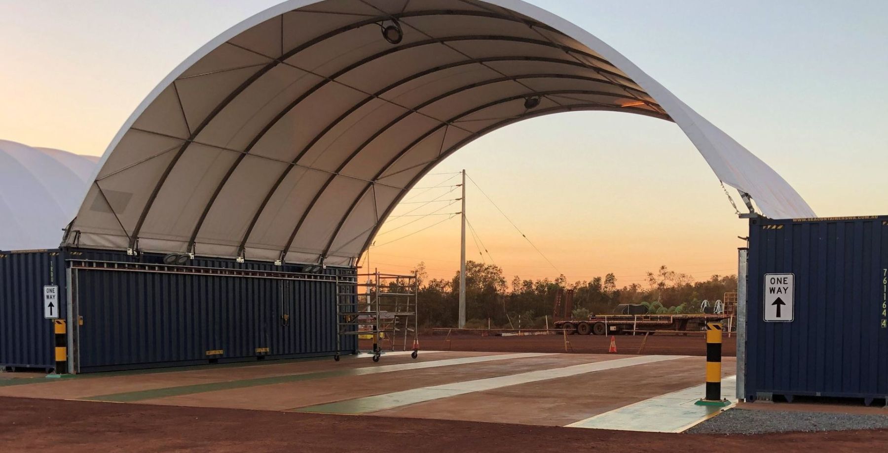

This is what I was referring to for sun protection "Dome Shelter"


Karratha_building_-_temporary_1-1-scaled.jpg
 

Heineken

Ol'Timer
Subscribed
Mar 2, 2019
339
536
93
Update today 29/4/21


It was about a month ago since I was last on site so seeing we are in lockdown again I thought I would self isolate and go for a look at progress on the dam :mask: .....................................definitely progressing well, the concrete batching plant has been taken away, I presume no more big concrete pours, maybe its cheaper just to buy in the smaller mounts of concrete if required..............................the other noticeable difference is I can no longer ride across the track to the other side of the river, it has all been removed now.


Only a few small sections of the rock walls to be laid on the banks, where the tracks crossed the river ............................the other thing is they have started to remove the shacks where the workers had set up camp............................I walked over to near the concrete access way over the dam wall and took a few photos, I asked a worker if I could walk across, no problem, he wanted me to climb the concrete stairs to where the winches are, without the railings, no thanks :eek:


There is still one dam gate to be fitted and then I presume it will be able to hold the water back, some of the winch cables are getting fitted, but the rest could be done at a later stage..........................they have it timed pretty good as we hopefully get some decent rain in a month or so, it will be good to see how much water they intend to hold back and for how long :eek:


ACtC-3dXrI6ShkFfZmBdTUR5ldDCoz43O_4jnmbGj56XK_Fo6jiNskSd-mInwPNWmwdnaJChtcXQkVX2N_qvMZyTUvWkGOTzthULHycfr0-d3lC-1FoG7fTRhIvB8aL8DNpf9GUzZkjxXr5MRuHv2daXY3_dEw=w1678-h944-no


ACtC-3cdVYBbK4zMp4XelmFfPUZ5Et1oFIbgRfuutQG9nZeE8P5Nw9xinWZiH8FbvT5KBpJk4ZRFsowlGJTXBcIQ_su6KtKO2IDFAp7uHmx8CcJa9T2Qm52eRPSdClmm_S7VRdVp-5lezFHCHEXSFW4Ae2XA_A=w1678-h944-no


ACtC-3cwQH8U4D1BdkMcQFCG_f4G9ZsmhkdrN42enQVinfd6vofiqylMZ6RL8UYz1p79WSSKkNN4pZUzHzckPnTsczSj94Dt7jzIlpN7UKbGa50j1Sfq-9LDd-rfp1A9sAna3pRiteNGj4TYMz6joyV8t9nS0Q=w1678-h944-no


ACtC-3cnrU_-y3qn2Hcia60NznANgtXg5blCpAbbJxXTtXiRxX_ecIdZgLggHrd0BQrr1meVtUJtm8dEMta4NoBw0VjFWJFT06uiILzvSbiCSYHhicT9VEzyt9nJHXrwvmIJctQFYzU8PGnjesYxwvWVF-Dn4w=w1678-h944-no


ACtC-3etoEnuvcy-QtY_aHHb03XcNTAa86Nw6bDiZNRYnopJcxwEmPK1sK7trVuT6zbrvc8uJidsK8H2hZoAno9oXRQWgXbP5coxew2UCTTMJAg_yyMn27Wzw21vkayXjwsq-a4bszGBE7Un37uU1mIG9YnIqA=w1678-h944-no


ACtC-3cWUkKPEy2Xo9oKw1wXdM960kA0l1EAt_WLiDSSSObvbmgrwjKqdWs4Eoe_gdgYvoklrTiqCDIE-SixXT0lfCxw4l6XxnBqBp0MxFWCIT7wHvaDQHy1C3khHMoR4m0oWcrVd32hA3VI0ZvP8Vu2AHJCDw=w1678-h944-no


ACtC-3c5zsjME5bzkFcnZ_59vvE9yhyXRdWYi2egR80VtP7k8ntIz0RyF7tsnJBCWgyVf9fNCMaZ5GTEyJuFmm0HtROSfxrmeJ-y0U1G2kBdWF64Ua8gOcZMcwDtGkcs-Pf8_i4cpOV20A2rTcFCiPb6QZWGGA=w1678-h944-no


ACtC-3eGwUu4fQS2bOTM1LBtNbOW_Xah7I3aOvTo42x_2wsSYDQLO_4rrWJYbXxq7C3NY6H54sMn2DOiM1KXap1TNJAbskbKgdkJ83_QeFBUo67BWswwp76NhikjR1mXlt20cBcpPuX3hYNNFZLY8MY-rlCyhQ=w1678-h944-no


ACtC-3e6Y8P15_oXZYM8BWQMMxygzJD1TxDpASKGkj14XKGpUuqi509VNhuKlMEYKXcbYNXjYPaSUcjwvgFGYyb6VKo4iIvBTu0k9Y15u-2SkgvbvrixPjYLBK6_XQLyowE0sWNBxDk8FGotta1ji1fbpoZ40w=w1678-h944-no


ACtC-3foNyKmtBAbuBxfsjsv3rRHCU0y3RzVY_ZgzeGhFMGUbqc7Qrhb2GuD3E80A_oFVs8Auh-bedS2787IPKdYc4Xi98gDeKKWG_wyWKyMTTGgT6l8i5G6cTdMPuNtUWC3po5GKhFhAUushcoTGN8f28jZfw=w533-h944-no


ACtC-3cUaPo1e6NtLpMnBmdnxT0hEVJkB5ag4dtZ1orz6-TQvtyETc4gJo1MevXoqCUiECk3kTZv8g6aU8nof-oUwHPtgaHKtGOCeKkaKn5x5gpmRpzLUs1EdDsG0C1YeJN5vw3T7Fu6qni3JWkSilw964Ka7g=w533-h944-no


ACtC-3fuek26pJOl8df01HX-ZXkyTx5-f_xpTsxLeEPkECrtnzJB8kRCzBXZawyQ5Itd_1tMK6xzwjJh2gl9MHqQNQGtkTirIW3jdKujhY-rvuRI-_PJmgNGiuSyHmy1RjAbodfsE_6pytvQ4n3FuazPrDYKtw=w533-h944-no


ACtC-3e--IadhEeeyGKcaKu0nO5U6sbMUoBmiTtwE0Ib93vrhwTKr4gSxvYsHg_HJilw_EOod_T0Ctm4scoJs2engJqNPHAD2Nc3lhkNEwkJ3BAW47dOKihPQOiZSQ_0M86S9Ga69-b0K1bUyX1n9gtI0qZU9g=w533-h944-no


ACtC-3f3IaH8pTbTDHHaIc0XM_Wvio5arqmBxMIsygMSIoZKBywGVOP1fvOMQVVMc1vKimchlB3MmBjBhfxTZkolctzjvdJypaUy4qECea27kfi_Es40xUwkCGzkwO7ILCRPL4kl8L5f7Ax4niD3v7VtxXZUJw=w533-h944-no
 
  • Like
Reactions: Oddvar and Moto-Rex

Heineken

Ol'Timer
Subscribed
Mar 2, 2019
339
536
93
So I went exploring on my X-Max again this morning and decided to have a look what they are actually doing in the river beds near the centre of Thoeng, you can see the earthworks going on from the main bridge crossing the Ing River in town.................................They have diverted the river to next to the bank whilst they remove sand, they are carting the sand down to the dam project ;)


ACtC-3dVCmCQW1sNMwe4_uLVNSRHRW6M_w1MBBa3CeWYyyhKr1_KhOdvDHhzowfrjH9z_Ww15RfP5YY2LUW1_NfThqm21ykjE2d8krMs06Xy53yaztmBf8BP4jIYPuz9x4xwCH-ccQH2Dc99Div3aMM1tx6o9g=w1677-h944-no


ACtC-3f9panlKdnkWnQWHPS2oycyVE0rOlg2-TRnUTy2Zg5X8JxrDzKzDLqNVJdedEzfB7x1oeLs1XxdR0GGcyM_2kKvUj2f9bESm7WbWUCjyxTxfz2k2Lg66FtX7hHAyOJmRa4GL90nRDQhxu8EiKl9ReH68Q=w1678-h944-no


ACtC-3ecNnSFF3o2BjeEexGkD_hq7kpXxQK1TTv-r0nynYQ4NFoeDIU9kSyN5fZz7fyH_CWWnAyZOjoWtMjpMD4UgPdCg2cwXAPrL4k7XTdEIdYoLN14oLnStHZy4tqKEgBMs5XzLRxD60sY6aklYs7e2wAPJw=w1678-h944-no


ACtC-3ffJc1BERUCTVAyvdGP5rFXX2F0TRbBCCqQfrjTktiTkOitHMhdIBKRfrkEQyYoIo_nxLhvmRuicnaa0X3I24NMMZA9cHKPe6C-q9VmKypVKDprBULYVJPzNadyVAWtuRetQAl9qnGgqdC9zdqxmBJJBA=w1678-h944-no


ACtC-3e56Ej-Ee5YNFK__efHgv2Nw1_pD8VWam3vtyuRvZDRJzQPwoS69H5Whe9PLVDnPfRUz9NJPKbWdP62Y5X-NPfI9nacWHHT8oiTIckDvzsr6auwjPZzC5_TEh6djusQmgk0B-KmqDBvub0kuJ_Ze_pVNA=w1678-h944-no


Just downstream from the Hwy 1020 bridge in Thoeng they built another bridge over the river, at the time they were building it I thought it was a great idea, until halfway through construction and I realized the bridge is only for motorbikes or pedestrians, would of been quite an expense for the few motorbikes that need to cross the river................


ACtC-3e46GyNPleaj_clFkOQtwyCJoMTQgxwAYqaVZbgrXa91ORqQU_wvmrbx7RM_MFaWl22ZXV3YV4T3b9-mJiUWWlIfgpjKsLtN54n_S5gur0B5VfhVqCup9qiQ6GD-cghCMhq07_TrXroWo2GUBQLAIEUfg=w1678-h944-no


ACtC-3cuP27IYxV28hD9EYrYfFwnzcs9Ddpfy4lJdOokc2ZugA9LKn7SSArR804TP5dCdjS-GKtXSczFgH4XOr5sqoUqi8PMg_b-jWtDqXfNz5p2AUrDpVksDlvk_ZpE54huLSlMdPquv4u0Z2tl1Mn4cS5KMQ=w1678-h944-no


ACtC-3djO6dZzDzweH6EoNVRokFsdqhRAnxD8-kBu89HAqR1YosoNx4UO-v4YHEu5JMomhhgeuvRh1FppIQIEKFpHNeIP5R6asTfCLc9MvtU29ktqpYVSSTTgwT7lKSt7u2oEh-OwFzfhTTzzC799ZsrTi09DA=w1678-h944-no


ACtC-3e1dbIWRvqKtlvZ4rE0QnQa3q300BawX2H4NOHpbdU_p4XzBs6YpS59OlSE0F385wFgvTK_Wry9lGysxDzEX0-BJvwpvnvqL7ZliiwByursCjBds7jI2YwU_Lc4OWp21tRhDwf7kbBz92PjvNYbSu8x8A=w1678-h944-no


I also went for a look upstream of the hwy 1020 bridge over the Ing River.....................the new pathway that I rode down actually had water nearly on the footpath, this was 2 x years ago, lastyear it got nowhere near that level as we did not have a big wet season............................if you look on the bridge pillars you can see where the water levels have been in the past, it would have to be 4 or 5m higher than where it was today :eek:


ACtC-3da4C2EIc9EBfOWvUzlQKPNlufOW1hww285SjPYtK7uQuHyrtqyX1rEs6gfWDB7wEOANs2szy4SFBoSYtmunaGajuRL-x3mJ0KzASlJbgCBwgLjfc1rwyWNFUYToYnOXvMZ74sfLquvmRYsIR1eHZHnxg=w1678-h944-no


ACtC-3ew1UGw0-7PIsFuYKFHV141BCzOewlEsqQR5jb99cogkbcENWCEgxsF1dKOyv3qxGW71E5YX6PjhFnE7fPC94-hJDus6UxOgs3Cd4P2-E2nf_BWm2iNCxjCc68B5m1DaHOJzDmUEEBedZHgsLLdUtzsOg=w1678-h944-no


ACtC-3es0ehhaGxRRT1hDYGKTfVJol_m_bmarEP6MNUScy4QMYO3gLW-EaPTMGG7nzM-sgMXFpo5ZW_tB-THlMV1QsV20CbKljDtvoMzSckdLm6Boieq09h-qQsqS3kYQEll7h4bEBI7Lbs2TDwOtwvIFoOOlw=w1678-h944-no
 
  • Like
Reactions: DavidFL

Heineken

Ol'Timer
Subscribed
Mar 2, 2019
339
536
93
This morning when I was out exploring I rode the X-Max across the motorbike bridge over the Ing River and decided to turn right, most people turn left and head into the villages there.


When you turn right the gravel road follows the Ing River, it is newly formed and now you can follow the good gravel road right around to the back of the dam project, probably about 1.5km I suppose................................it gives a different perspective on the dam project from the otherside of the river and the different angles...............................I noticed a bit more water flowing, I presume since they opened up that sand wall back at the bridge in Thoeng.


ACtC-3fpCsy0Jj0KEQy4_YnGFaU4sB_RN42of2pWsAZT4DAI2f8b-JenvNB44pYgw4lBERQgIhLvbEqHRT3s8pwVu0r3Z2z9czOYAq-Z9z_bqLAZLY6w7GDh0tAV2KJLQKylnBIg7abDPvpdNb6tTH7DdvEmCA=w1678-h944-no


ACtC-3cz2DPViqzuFGfFIcO8WWViDFBaYGbXRR8CHVX90YAYUQph3m5TiezOvJlFv44BmqOkB800INn7gISepW11FBClZ4bQ8fBTMU4medn51GXnv8AMppekHD1_mYSL5gLByzwckKusO6i3OxZJ82xtScYCxg=w1678-h944-no


ACtC-3ddufB06x2O31rzeQFyhHRSDdvw_ukJ9h8NwnSi7ibI9FncM-Cc1dh2qPh_uANbOFu5_PMFQh5RTvcynYWb5XEMfIGbkSrziCkJljBH7t3aq47wMPl5Al8JV5u5wg4MvOEQvnHkZg5gGFq4FvhB2LNRkQ=w1678-h944-no


ACtC-3ewvZj8tTXqWAk8vQRqM49THv_zMyVMIXdPwDaP1-7x79F0S16EJujm6wFkZ69Gzcnj_d59C65yOSKcQEQw9uCpLoeGQ0l_yM6aKWdcYPC0FSYQ39UJhglK5V2rkhUfOXN_OQhNxy90RQNClb5kcA-8IA=w1678-h944-no


ACtC-3eAw_KLDOcPb2Vz_vbQizM6SjOCgMoLB5hj_xbTjZvWgKMEgaxYva8hq1v-W51X4-0xn3rnBXwBHRT3tzktqvkYFb8QJQ1i8j6WX_ZaQrocNOvGZ2op4s3XOETej-YfZdgK_TrUYdvG_2SyUSUbkH_jWA=w1678-h944-no


The gravel road continues on past the Dam Project and goes for a further 1/2km or so, strangely the last few hundred metres has concrete posts on each side of the road, not sure why..................at the end of this gravel road you can see a crossing where vehicles have been crossing the river, a bit to much for the X-Max today, especially by myself :laughing:


ACtC-3eSpeSZRaacHdCoezvBV_g9FUR0xdigKUn_b0QYp2uxJb3MLEhlG2TQek7OzbB8NgsHaH2sSte4A2PoppEPhYG61WyqnLO0CwrfuJk2SNJtGV0vj0aVYM_8RGrET8u8nnfHyC2s5nyvh2jUYwW2rJRbOw=w1678-h944-no
 
  • Like
Reactions: Moto-Rex

DavidFL

0
Staff member
Subscribed
Jan 16, 2003
14,811
5,619
113
70
Chiang Khong
www.thegtrider.com
Interesting that dam is downstream of Thoeng city - for flood control downstream?
I can't work that one out, or for irrigation purposes only?
It seems as if you have a confluence of 2 rivers at Thoeng, the Ing & the Mae Lao, plus the smaller Mae Loi.
They all converge all upstream immediately south of the main road junction by traffic lights.
That looks an interesting area. How far upstream can you ride by the Ing?

I wonder what the view of it all is like from the wat on the hill?


I must come and take a look sometime.
 

Heineken

Ol'Timer
Subscribed
Mar 2, 2019
339
536
93
Interesting that dam is downstream of Thoeng city - for flood control downstream?
I can't work that one out, or for irrigation purposes only?


My guess is for irrigation purposes only..............................................the river basically dries up for 3 or 4 months per year, more so in the last few years, lots of farmers pump water from the river, especially the ones trying to get 2 x rice crops per year.


I wonder what the view of it all is like from the wat on the hill?


I must come and take a look sometime.


Magnificent view of the area on a clear day, out over the city and further to the farms, look the other way and you will see all the prawn farms, its a 360deg view, and alot of people dont realize its ok to drive your car or ride your bike to the upper level, even though there is a lower carpark where most people park and walk up...............................it is a steep climb, just remember that ;)
 

Heineken

Ol'Timer
Subscribed
Mar 2, 2019
339
536
93
So I had a bit of spare time this afternoon after my 1pm Dentist appointment, I stopped at the bridge over the Ing River and had a look at the sand removal progress, 1st photo is from two weeks ago, and bottom photo is today :eek:


I still think that they started this project too late, the rains will be here soon and alot of this sand will be washed down stream, unless they are stockpiling the sand away from the centre of the river and will load from there, time will tell ;)


ACtC-3f9panlKdnkWnQWHPS2oycyVE0rOlg2-TRnUTy2Zg5X8JxrDzKzDLqNVJdedEzfB7x1oeLs1XxdR0GGcyM_2kKvUj2f9bESm7WbWUCjyxTxfz2k2Lg66FtX7hHAyOJmRa4GL90nRDQhxu8EiKl9ReH68Q=w1678-h944-no


ACtC-3fpMXePOgfqem2N0X5rAyEJRPRZexg2Hu_nEENcoQkrqx0eJEmAYAM2XpPDoIRrSihkrv5qWAFIj0rdwxJbEq0zgGG2g58lDlapryQYUbmhcTv4-oc8O9vkfnQCPtTgPZmxw7dIBU8JYJHfjGWBC1-D5g=w1678-h944-no
 

Heineken

Ol'Timer
Subscribed
Mar 2, 2019
339
536
93
From the town of Thoeng I decided to take a ride out to the dam project and check on progress ;)


Looks like the project is running on schedule and if the rains come the dam will be able to handle the flow, all dam gates are now installed, although only one is operational, they use a big electrical motor driving a reduction gearbox with two output shafts, which are connected to winches, which coil the huge steel cables too lift or lower the dam gates ;)


Today I was allowed to take the stairs to the top of the structure, could see exactly how the winches will work, and a great view from up there, they are in the process of installing a tiled roof over the winches and electrical motors, not sure if the public will be allowed up top when open ?..........................maybe just for the maintenance guys, and of course Heineken :laughing:


The lower part of the river banks have had the stonework completed, and only a short section of the upper level to go ;)


ACtC-3efZ71EhpfEPPmNp02K6QgttnYYNDDiFaihX2A7eObE2EuZ28IC-8hF0qvqp2n6jxgSmTD-SUOZCcyxRUOSevORZB22grz5-KaFavpWd6kjKt58FyA228ZZh_njbb0SacNDErI7SB2495_J2qRxtEOc8A=w1678-h944-no


ACtC-3eMoVo5RQWycIdbt986FwFpBKtKwam36Dqji_84pPuJwHFLrnbLSqgOSGzz0K4vnROMJhMr4cznefO-zJwRAYsUgx7uY6yhiKNySU01ksSEQfeIfY55G16HHdLmetlAneQU-sjhi8hL6CRqfwuQkKJSBw=w1678-h944-no


ACtC-3dQqgqWg8cak_-Gli0vldrUCRkDsFVh5QXnq36lwH08nh3V3l8xl2QYdQkqxj2lClyPtsk2_NkwCH8xNIhVOAxPs9reiQw6kMagwD-AH7o8CBblWQG5CMkbPanP3hNHJJk_o6Alm0jZCTGYrBJDKQYPJw=w1678-h944-no


ACtC-3ecEGx2zZTNqFO-FOHKAx6etsnrfyIx6X8HXGM49M7oX9DZ01xsqz9FRuzGEC6zIWvuO_uwB7MVo__UpHypOPQThb3_gYAblh90k7XqeufbyDeMgr1VwK_ml806q9zf45UhoLokCNlyhSzzsS5noQeISg=w1678-h944-no


ACtC-3eFsnKhYMdxPZeKtslh2-aKNtEK3QsUQhd-moz9N-mf6pv6xcyYxUJ9LhKNNdpnb6J7qeeWuETdTDBgRltsv63VHhrNBYl3_SNjBtXnUTmse0ges2_RJtJna0K14cC0zWHrRCRmN7TYbca9W5wOp7wuOA=w1678-h944-no


ACtC-3fyV056Sdq4g_KejXUCMDH6LOucmKrY4XAGFoVmnKw-vWq7gDcyaY3tDJorU7glWt3XOGHixrNBxm1xtqY7C5IBAh2PK2Zk4OM7hHMapxf9G2RTq-E3raiW4shL9NlifCbBqxstdLHCKksEdZ4WPak_Iw=w1678-h944-no


ACtC-3fyr8KNvrTkC3Qe21j0KAedJothGVEREeU6PnpQbw2Fa9Kkwnz7Fq_cWyPV7YVH_WAwJAU8BoDLT0QF1sZYkakKgW0dmPp_eoLsb5nSS74-ZgLco_bPAZYc9vRXBL7NDF9PTfQFTcWKLYevSxi-08WssA=w1678-h944-no


ACtC-3e6UqPbzdzT3US_EVY7Ddglu7P-OuaX9TSNqmkRTY1r5_VnbUjKIuF43rX6Nr_Vt3At2huDEjcFFR1h7VelfIU4_zOockAA1ld8ZA_oJX5iIaI2whyWyrc7OhyuLaIdBy-9Ji6pJWuEHsg9Joi6mCCGQA=w1678-h944-no


ACtC-3cSPN1kXm7VjxYIEoy8nr1lvQflwpEkSExwXzvtHcRrAL_SBQIRdPiFlpb2AT8JC7yV6m4DzpnMpyUQ8Kc_Yut7V7R6OCTmEqJNDAi28xGRMmTi5K3YqAUIbwFNn1eJYKJTEziaDXr1yDZNY6dQ1Sbpyg=w1678-h944-no


ACtC-3clUP_1l8DMguPqVs7v2hjozQlVttxeJdGQZJLXunU5BI7_IXM82QY_Zdl8o4o_bNCgEXRtF2v8m_3yFj0kSBOC8MS6umIe193GrW1Rd2yeODLVPKUpHhLoP4KUb2lBzDFtVnIL0_0h6MPr98jBNj5t4A=w1880-h944-no


ACtC-3eFr4jSQmPN56nFzT2s6_rQBuNlgBMwNYJRACMRuWbUEyX3xM1ZTxxwACyqE-9Tx0GA5TV8Gr-P71HD8WjrapmvH7nQOA8bEONQ4wAN2DaEOXk17WTNdDdoAut35WaK9gNUZ7Ok1Hk2vlvdel4ehDT1Gw=w1678-h944-no


ACtC-3fFpYW-UMoPSgprRTHiCfNqEbsPtvmRlEYaFQbfoLAeSRvBIJ-3S-o--upE4fTiM7974B-yh3JyLVrfecquaWheQlZLk1nmIu_KixQTg7JS-SITW6zIEFFraBrtGXIoSfeBW4Gizw4CaDxu5O98QP_JNQ=w533-h944-no


ACtC-3fWF1gaTOsHq-CRjJn8lRUBspdniQTYEQqUJhbBzmqiBTk2-GEkj1b_MLnxlCCBXv1dyPuUuCX038bWyJEFs7qDw9wBUY_h8pMsrHSfvieWn2IsabSUFdPSFKJK66Am4IdDd3hOn3yY1u_P07yD36DXYw=w533-h944-no


And of course the usual Thai Safety Standard which applies to all work sites :eek:..................................................


ACtC-3f55xJGIgTdyo75zJLWERVewv3Nl1TzNtIY-FvxT6Yuh3xSGAZymEhcbfj6sK1dVXJ7Iuy8d-ZUADbZWBz1gkwHjSZPzd8C6R51XYEvawTkrtXZXwARxyY3AwsdMcL1m-FAuqcHQ4Quw0O4AvudPvGgzg=w533-h944-no
 
Last edited:

Heineken

Ol'Timer
Subscribed
Mar 2, 2019
339
536
93
What a difference 24 hours of rain makes, we had our wettest day of the year yesterday, rained pretty well non stop for 24hrs, not super heavy, just constant rain ;)


The Ing river has risen nearly 3m, hard to imagine but of course I took some photos to show, nearly had to stay at the dam as the X-Max doesn't like going off-road :eek:


ACtC-3dYAPWJ1IBv47XUVMmvQbPRpl14JeLE9WFYSCN-pZC7JdiEjYxWfoo4_7Kaxyjh4UdhamHZX4tqCI8ZpOU8rroGYGnHxJKDQaplysy90YGKY3QABHKXBLXmfIDFJvzGoaTbMTmLyXAnnlYhEbnv4RIZtg=w1678-h944-no


ACtC-3fJrOzCNwES-udu86WQTaWFz3Fe0pIB8WDahdXjKtQruy5aKmaVJDflDrSTZBu_yQLbnW66M0fXj6DvkS5ffgBdqK3sEYyoM6DK9Hlq9tZ3vw4dAKY8R8-gxCEXZgcFEv_B2fSdSTYKL84uasOze0d0xw=w1678-h944-no


ACtC-3eYjqE5vLf-Qgpa2YLFM1N_V8Tgmaw5FaYPkdIfcvr5v5ZRG5m3ZVQNOoKLIgZFJseHI7EAxF425Zah46NhmC6jp4G_3rQ143lySBjvYPvClCOljMCdywXHomsOdzuXClcR73ACwxXy4QUYIXhqW8oHmw=w1678-h944-no


ACtC-3cIvP9fS_g4Pg-vU-AsTtz4b8EdDrPFGrZCrVMQBUMYlXr0PqUh9jWrh0nKH3oeKZCms9OA4u3ftIND1C6MwXKxxVFFuO7F0kyLC5RTNmZitLREX46dRKDk1_hiZYMBDZE1_4G6hDhLIk-31z6Ja7yG8Q=w1678-h944-no


ACtC-3esyEu8Gkvymk9HNrn55xbUeJfsF5at2ML3evtqwUIBi2SWAKCv2S8aMLZAZUgyTGSq0zneOXUd6CIrhijAnrFurgbxUhjtb-_FDYNh0_zBuWupsw-EsCRrRFAvo9YWUNCnIXgTllp7DlHeIh8Yl735ZA=w1678-h944-no


ACtC-3cScL5U02eihPRVMJiCjem-52QwBfwVPOo63uCCmf1N35pptOk1CiNKiYBp3SlueXgnkIuef17rDidlgPYmwaPaYY7XfV56va93gw3fegwpRPuQIiknLc7HJ3S_PFWgP42Buu2_F_sc8RGC9rm3w8qe0g=w1920-h692-no
 
  • Like
Reactions: DavidFL and Alamo

Heineken

Ol'Timer
Subscribed
Mar 2, 2019
339
536
93
^ No Duck Paddling :laughing:


The actual road was very slippery so I thought I would avoid the slippery clay and go down on the edge of the road, great idea in some sections, not so good in others ;)


Biggest issue is to remember to turn off the Traction Control, otherwise the bike cuts engine power and then reapplies continuously and makes things a whole lot worse, turn it off and control with the throttle and its so much smoother, the X-Max being alot heavier than the smaller Waves etc doesn't help either ;)
 

Heineken

Ol'Timer
Subscribed
Mar 2, 2019
339
536
93
So I had a bit of spare time this afternoon after my 1pm Dentist appointment, I stopped at the bridge over the Ing River and had a look at the sand removal progress, 1st photo is from two weeks ago, and bottom photo is today :eek:


I still think that they started this project too late, the rains will be here soon and alot of this sand will be washed down stream, unless they are stockpiling the sand away from the centre of the river and will load from there, time will tell ;)


ACtC-3f9panlKdnkWnQWHPS2oycyVE0rOlg2-TRnUTy2Zg5X8JxrDzKzDLqNVJdedEzfB7x1oeLs1XxdR0GGcyM_2kKvUj2f9bESm7WbWUCjyxTxfz2k2Lg66FtX7hHAyOJmRa4GL90nRDQhxu8EiKl9ReH68Q=w1678-h944-no


ACtC-3fpMXePOgfqem2N0X5rAyEJRPRZexg2Hu_nEENcoQkrqx0eJEmAYAM2XpPDoIRrSihkrv5qWAFIj0rdwxJbEq0zgGG2g58lDlapryQYUbmhcTv4-oc8O9vkfnQCPtTgPZmxw7dIBU8JYJHfjGWBC1-D5g=w1678-h944-no


Three weeks later and the level of the Ing River has risen substantially after one very wet day (Mon 14/6/21)........................................


ACtC-3fjcLp1lIZMo2zEgJAunP-1SOIYLveNnhrxIboidcDXSbBfbgg80dUlP9uO7NsAj7tDmQ5SYdq0zwQvBKkIEaUHxj_LxA1qPyRC_Gord9tlMxz4ItvH3L_JBQQS-knu-PPK-vIJWiVTnKYtxXTtAQ2W4g=w1678-h944-no


ACtC-3clu057cf5ZXGqc0emJEn6_Z2jSL0omWovD4kpLaxTdm2ux5fZzm4EjwIU51Yhg9gZqXjQwkhKM6ZprFFj4_AVet1sNn3I87obX6NTyf_tcJkYgJs2YrfV6urlKl0UVWIO60ofOQPukoSCq_UYJTWrFEg=w1678-h944-no


ACtC-3dwUdpngYRTL3xWlztCicZGIgcUSYHinsXSe_3cGRf_Rrd7_BztfRyuqW7ZiJ5cBrwe6U769oIQ9EZYrd6Uy3q-9pGVUWSycq893tLALO55OqbfrK_-LQeDSu8O5BZ2_AWBh1hu5UVKk5R4ZfpwwmOnQQ=w1678-h944-no


ACtC-3eg23pZIq1qRYJ1H_5cYfiL0V-I5qAS_tuGuGw7dR0E1MAZz7eeDT0dIZg3CwKuRAcvzJq4O4LfDoVKoqFRyG5dMeLy_Y9onm1GakyaSnQlGkBoOojEKRykP5L2LgiTs7fn5PT5fTAKa7dsvWSxlBEtMQ=w1678-h944-no
 

Heineken

Ol'Timer
Subscribed
Mar 2, 2019
339
536
93
Beginning of July 2021 and another update :cool:


Well it looks like construction might be about finished, most of the machinery has gone off site, only a grader remains......................................I thought they might seal the roads around the dam but maybe looks like no, they have put a roadbase down on the clay so even when wet the roads are ok to drive on.........................lots of bollards have been installed, just painting them now to mark the access roads, on both sides of the river ;)


Another addition is lots of solar powered street lights, great idea as they seem to work faultlessly..........................still installing more atm......................................I would of thought now would be an ideal time to install some landscaping, need alot of trees planted, and beginning of wet season would be an ideal time IMO


I noticed yesterday that most of the dam gates were up so no restriction of the water flower down the Ing.....................................maybe they will be lowered after the wet season ?...............................no idea, ill keep going for a look and see what the plan is.............................water level has dropped significantly from a few weeks ago :eek:


AM-JKLV1KDrw9NxO4LHM2TmOWr9nbaK9z5dezqZDyKhXacKTcswJCUajLzGw7ehAAg-V_tSsTXXzJuf6m_BA2IpoToLjPcu6tyn1eK4QvsnNcPK4kdW4DkHdGRmKhzJcZr9OP2cTt6C2dIAHrdiycIBPkWgmZQ=w1678-h944-no


AM-JKLUH5Ej_tp0asCOeeQ0blJ9SjGxUilfF9JNwm_OvGwu-xJM24XcQLZTwrGzg0TuNJGJxXJPpTu5uB5OQ654-NlpKKOKL005RI_-fuHN7zkZuF-_rg08zIxiz5GCf1fD9e2sYClOnu4DT6aD-C9VFaQXJdw=w1678-h944-no


AM-JKLUfVIwyaJdV8O7JcuJQyydmsUKupj-h1JbJiUCZbg20wFEjUAfh8JFJnPSGZZ-PtSJjBAna5p6nxcJsUaGfSSKErWCo4pM5RUqUnqR8wErfZXTp4H80XLLydPQxLcxO-QhOjIP-WLpkhkhEgZqslcFxxg=w1678-h944-no


AM-JKLXs_jYqeFy5rKd00nakaSuxizwkistfMzjgaXT1N_JjFgaH4sYX7r6OVTYz9PYt9sullJFGHCbPv--Epii1W---pbJwEMXwGaIageiqa_VmowkKZt-Qw0vfNQupYcfoMmNafPoP8IOENJ4kSqFw6gkuUQ=w1678-h944-no


AM-JKLXkLE55ltmGYCRqxYt6Khs1s_U5Ww1seFeW9ZCffCiSbhh4g9mPGndU4M2AZZ3yJV93mQsivobVKTKJWuJkoJmyug5YB_5ogCKmO2AcnwrvJBLuQ80GoJpjepOyOF10t_RKF6WWFmkbsouQ95pXI36zbw=w1678-h944-no


AM-JKLV_YLH6ln2MjB1XgWQqVwl7zVecN4ZPffQtdx4C5peku9aiN8SFq1dZHDIjoqXGGr42FW7LCTo8O5oktUtfLXnWTQhBnw-TyRn4pGUkUctFTOaUh0oaSTu_wKqGj18zNdJPt27fyfa8_MUIe4Yki-8pdw=w1678-h944-no


AM-JKLVm_p6jFQZXhk2YwxWWvv8ELmP5lApZWmK_A5onz39Wrmzs7Fgy0g0tCVEnean4PmIY8Py6uef9QlOBrKD5kcbOpKwzgiGyzs3W1R05dpVpcJSlWJ3jBqJzeJOI1OA8QyG_hMBd6ATKalqkPFk0jrJhmw=w1920-h615-no


AM-JKLWZlk3kk_HzAhuEFaksdY-OUCmc5aWCEFR9jRiJHtMS6pG0qLT-3LzH2csHgeL5mzBaIdbC6IMw8TjoK3pFfEErvL_Cd72CQxo5vGr8sVXcpejT8h7f0sdTHrVeD1Q9pKHuxW2XznYdeuwssAdMmhhD1w=w1678-h944-no


AM-JKLX9teF2O6a48k4Qq40Hhs5JigQ6Fp41m9xnmaG4PR_RgdZvnq4wiDl6TAA2HpvRSoIpArWWHUEM5P2_ziaq4FJkRFFRQPNy79R4S0WvNbQJ-3uJl-X296oxiAOwqNVREuoYZH2np-LHG--R3-1saTA8QA=w1678-h944-no


AM-JKLVuZzdRGY0DPOOmaihmL71by9WkWfIHfmbaINoJzvI0tnQYsEz1fKXO8xRMXNNE-KdWaZWK7ryqEcjVqvk4sytGtABaBuDrRYTokxF3sAeglp4aMKLafArFa5JBn_m5z9cmhThVp9Oi2P-XY0GZ6cq4GA=w1678-h944-no


AM-JKLVfufq9ZDLV10sr3XQLxlKPvRaxFIUb7vJFWOeTkXp4ikjwkPM_bIImu2zscRcZurz6lci9kv96zyQ7scf6XZTw7yx2Bunkx0C72k5EdtwvfqUV6EpIud9JpeAe1g17fCNUQuE9mSp3kRFGktobinvdzA=w533-h944-no
 

DavidFL

0
Staff member
Subscribed
Jan 16, 2003
14,811
5,619
113
70
Chiang Khong
www.thegtrider.com
From above & the info on the teak logging & riverine transport

Transporting Timber from the Ing down the Khong to Saigon
Moving timber out along the meandering Ing was not without difficulty.
The teak was felled in the upper watershed of the Ing River, around Ban Tam Nai, Ban Ronghai and Ban Phin near Phayao town.
Floating the teak out usually started in June / July at the start of the wet when the water level in the Ing was rising.
The logs were floated downstream to Thoeng, where some were processed at a sawmill beside the river, & /or made into rafts.
From Thoeng downstream the river was more difficult and meandering.
Thung Ang 5 kms before the confluence of the Ing & the Mekong, at Thung Ang just east of R1020 & west of R1155 Google Maps there was a huge horseshoe bend in the river that caused log jams so the French cut a canal through to alleviate the problem. This big bend was also used as a storage yard for logs. (I wonder about all the other bends in the Ing, through the Boon Rueng wetlands?)

A small trip out from Chiang Khong to Thung Ang, and after winding through a soi or two, following the GTR nose we found the spot.
1626178517796.png


1626178599730.png


1626178577054.png


1626178642706.png


1626178659125.png


1626178781595.png


1626178810900.png

Thanks for the company Michel Chiang Khong.

How it looks in Google
1626179021362.png


  • Like
Reactions: Heineken

Heineken

Ol'Timer
Subscribed
Mar 2, 2019
339
536
93
I went and had a look at how the dam is now that it has been completed for quite a while, its obviously operational as the bridge over the Ing River (hwy #1020) in Thoeng township shows the water level alot higher than normal for this time of the year, usually it has stopped flowing and just pockets of water in the lower areas, the level looks like the middle of the wet season atm ;)


What surprised me was the amount of water they are holding back at the dam, the difference in water levels from one side to the other has to be 4 to 5m, yep that's correct.......................it would be great to find out how they intend to operate this dam, maybe let water out occasionally ?................................I have no idea, I do know that the Ing River on the Thoeng side of the dam looks great and everything very green, I am sure the farmers on this side will be making use of the water level aswell :cool:


AM-JKLUiLnMZ64RrZ0Bos0vkcL5KHg8Y-EWu6T3pbnDf0bd5KPt--8Mnsxq5y8TA4fZl3dE0GmSMTOWRNi8yGvP0nXAYM5rd58wP3-dJ-exbLOYzDlEkKHmN6_sdetnfSvoxaCxWAItUNeP-qF4Pao8Y1aQwAw=w1678-h944-no


AM-JKLX8RFIIOeTnVbvrkTo4C_GuERjNiX8Nrtefj5RGEnabAOvYf0AiJtZl5qYmNg2FObK9irWClYwRP9kuAPu169Byt_AhGAT5kRjTbx1dXaU9BIBDOI6A3JOtMQ_Xw4YVAQCD3jEYOJOP5BMVCEHZebw9Og=w1678-h944-no


AM-JKLWvn4CEQWRNX8Lk8Ds0jveiK87nVRoYUiMdJHFwqsKZArPBQsXJz3TwyIA3_N-sKnOKKH1ZNrkG1zO2i5eg_djIQ4ThuCnPP_EAN_BetPPcxrcGevVzXqxHHDYTf7QRtCLUx1OZBNmX4TOCloBFuPmn_A=w1677-h944-no


AM-JKLXzW2RqhUUOpLRwXJlXZ06SdYXoTGjrLIlJFaC3maH9zU1JDcRwDX4g6kx97Hs7wkGkYUiGmuruQe0tvwgXw1PyxI-SeTsJP3spPTACxwGsJ9PohSovmSL_HghzCYm7fIUWeyc98gPwzPNdk3CfaFUXRQ=w1677-h944-no


AM-JKLVLnrUh-ll2k1k7E7Mw4kgjaMQmpj_-KgW6R2Tw4yOU8sdT0kMISLM1uVksCSKBRZ02Vp3zq6o9HUiMfMfBP5Av4gGlCW4sNSXz0-Eigy_aKo-7e00yG6xyeStHbwp9IZi0aW4OysuGTU3id_UATPzYzg=w1678-h944-no


AM-JKLVthgd6W6mjNgmMf796WGuGDdO5pSTgSQ4vvWI7W8cIgmUCGm7Xow92t3t7M4OQNc8AKx9eU-4uGhLJQv-XhjZ37_CxslhohIn1Mj1XxJsOjx89WyzH008CN2KabLs0bQL7gKu3ZYUCs30Qv2-L9RxIsQ=w1678-h944-no
 

Heineken

Ol'Timer
Subscribed
Mar 2, 2019
339
536
93
After my visit to see the dam a few days ago I decided to go and visit a huge lake which is fed from the Ing River, seeing the water level is so high for this time of year I thought maybe there will be some water in the lake, usually just a dry lake bed in April ;)


These photos are from April 2020 (2 x years ago)................................


AM-JKLXQIwwRIkQX6A1Huv5olvR_EXm71C42ApirBHwKFKbNQ03n0b0uPe4vNdIWcmSRBef0q6f8jF4n-NupSqwY-CDAL2Ya92CCb1PpsKNANvm4njqmZ06zmbQjbAPzE_ynTZdKHg89bTf429gqq9tsbT8KTQ=w1679-h944-no


AM-JKLVD48I8RPlorAPYpEuNpILjOdmsPV97Hpnstm9x3-5hzzChw9kj7Ki2m7Yk21STkgKxSWJCK5ICwRUu8pDxwLN12a3mzOrX2CtK8rvasKEJsDXoMZliF8uw-T9Ewxv8HYUySxn0DC9pd0ntscm7bzm4Ug=w1407-h792-no


And these photos are of the same lake a few days ago :eek:...............................


AM-JKLW81nMYskePPr8RgbC0BYGMtP40pBDVirUOk1J0h6BuhYjDjPmXu6BJmlznxPtzRHIkddJQGvPL2hn24esdjPpv7AsVd9-Xo3SZjbaq9yiFz3I45l3Atj_xiOuceFbgpvwKDSByJ3bVg-mn0MO4C-taNg=w1678-h944-no


AM-JKLVO3JUfW6ujv8XTXW8kk8GzN5AGMtqTAv_YAyExpluJoEXt_-F2QiBMLsFz2Is96TdBOQpIJDfAevLopLbHPDuQiDiN82Sez-kH13--4lLc-RAPrK97p3paFvZ5EZZqrWr14MVbO_rfnK3rvAA1ph-pOA=w1678-h944-no


AM-JKLVTutSgk1LqVTDh8vqbX5gIftJj3hxDDVLZhW-cxPJC1QwBn0ewTvjMlrWfPqXFC6rbScGZxnQSwlt1iJju_6bKi1tDUW_zCz_nx5QJF7sGjd9OfEQkrQO2jkIaEqc3ahisxgURTuqclQ8f1N5varoFfQ=w1678-h944-no


AM-JKLWIaKcWkJVqNn1baXdwVGaHuFmJUhdRRUgDSz55OHOqss68X6AHTHf8os_3ivoeiEZiu6dhbuszGLxEZib4nHYHP8BM3aRIrEIiEmIzZY5PwLzm6WHCkdR1djc9ytEx8abzc5mvl0-MGOVBtrHWPCueQg=w1678-h944-no
 
  • Wow
  • Like
Reactions: Ughetto and DavidFL

DavidFL

0
Staff member
Subscribed
Jan 16, 2003
14,811
5,619
113
70
Chiang Khong
www.thegtrider.com
That's a massive change.
BTW we need to have a GTR lunch at one of the shrimp farms upstream from Thoeng?
Do you have a suggestion for a nice relaxing establishment?
 

DavidFL

0
Staff member
Subscribed
Jan 16, 2003
14,811
5,619
113
70
Chiang Khong
www.thegtrider.com
An interesting bit of history on the Ing, Kok & Fang rivers.
These 3 rivers basically flow South to North & into the Mekong. The only other river in the North to do this is Mae Lao?

In the early Siam logging days, teak was cut & dropped into the rivers of the Chao Phraya watershed to end up in Bangkok.
But not that of the Ing & the Kok, because these rivers flowed into the Mekong watershed & getting the logs over the ridgeline into the other watershed was too difficult.
So what happened & who got the contracts & did the logging - not the Brits & the Borneo Company / Bombay Burmah Trading Corporation / The Siam Forest Company, but the French with French East Asiatic Company who floated the logs down the Ing or the Kok & into the Mekong to eventually end up in Saigon, Vietnam!

The Ing logging concession was given to the French in 1909.
Previously though in 1901 the Bombay Burmah Trading Corporation had the logging concession, but found it too difficult to get the logs into the Chao Phraya watershed by the Yom river.
The solution was for a new logging concession: The Ing forests would be subdivided into three sections north, central, and south forests. The south section, the timbers of which could be worked into the Yom River, was granted to the Siam Forest Company. However, the north and central sections, from where the only feasible export route was via the Mekong watershed, were given to the French East Asiatic Company. And so the timber from Phayao eventually ended up at Saigon in the Mekong!

The Kok Logging Concession was granted in 1912, after the return on the French East Asiatic Company was not commensurate to their investment in the Ing concession. The agreement was that they would harvest the Ing for 15 years and then the Kok for 15 years.

The Fang River that flowed North was an exception though, as the Siamese government of the day was concerned about the French gaining excessive influence and stipulated that the timber of the Fang forests would not be transported along the Mekong River. The Borneo Company had the Fang logging lease and to move the logs out they constructed a tramway on which loaded trucks were drawn by elephants from the final delivery point in the forest to the top of the watershed, and a chute or timber-slide to transport the logs down the precipitous slopes from the highest point on the watershed at the end of the tramway. From 1912 to 1930 teak was transported into Mae Phan and Mae Poi, tributaries of the Ping River in the Chao Phraya watershed. Somewhere on the headwaters of the Fang river there may still be an old tramway cutting?

Transporting Timber from the Ing down the Khong to Saigon
Moving timber out along the meandering Ing was not without difficulty.
The teak was felled in the upper watershed of the Ing River, around Ban Tam Nai, Ban Ronghai and Ban Phin near Phayao town.
Floating the teak out usually started in June / July at the start of the wet when the water level in the Ing was rising.
The logs were floated downstream to Thoeng, where some were processed at a sawmill beside the river, & /or made into rafts.
From Thoeng downstream the river was more difficult and meandering.
Thung Ang 5 kms before the confluence of the Ing & the Mekong, at Thung Ang just east of R1020 & west of R1155 Google Maps there was a huge horseshoe bend in the river that caused log jams so the French cut a canal through to alleviate the problem. This big bend was also used as a storage yard for logs. (I wonder about all the other bends in the Ing, through the Boon Rueng wetlands?)
Ban Ten 3 kms further downstream at Ban Ten, where there now is a bridge across the Ing, the Royal Forest Department established a duty station to collect taxes on the logs.
Google Maps

Down the Khong In March - April the logs were then floated down the Mekong river. Khamu labourers were used for the journey down the Khong, because of their price & Mekong experience.
The main obstacle on the Khong going downstream was the Khone Phapheng rapids in the south of Laos.
Depending on the season, the log rafts were moored at Don Dek and Don Khone & dismantled to be floated through small channels (wet season), or carried across Don Khone by the train in the dry season.

Overall it took two years for logs to be floated downstream from Chiang Khong to Saigon!

The French East Asiatic Company processed about 4,000 logs annually at two sawmills, one near Saigon and the other near Phnom Penh.

Cheers....I will always look at the Ing a little differently now after discovering this info.

A map of the logging concessions in the north, sent to me by JB
1664357564006.png