
Come gather round bikers, wherever you roam
And admit that the highways around you have grown
And accept it that soon you won't ride on your own
Cause the dirt roads are rapidly fadin...... etc etc...
Not strictly true. But it seems many of the old dirt roads are indeed getting paved. But new dirt roads appearing for theose intrepid enough to find them.
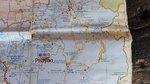
First, I was at Sakoen, just off the good old 1148. The reservoir there was overflowing, as the Mae Nam Ngin.


A little further along, where the Mae Nam Yot crosses the 1148, at Bahn Pa Lak, I went up north and a recently paved little road.


To Bahn Pang San.

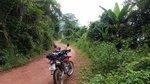
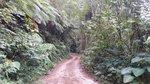
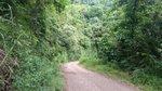
Then found a dirt road that is still a dirt road, heading east. Turning right here......

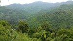
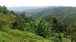
lovely little detour..,...

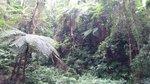
country scenes....


a technical section down, but not too steep.

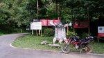
The dirt road pops out at Bahn Bannasophit on 1279. This road goes up north to the Laos border crossing.
GPS track;
Track_Loop north 1148.gpx

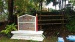
Riding further on east and south, I finally ended up in Wiang Sa, south of Nan city, for the night. An old style Thai town on the Nan river, that appears to be a dragon boat racing centre. But could not find any bars or restaurants, so ended up eating dinner at stalls in the temple.
Next day, headed out to an old favourite; the 1243 eastern border road from Bahn Sali to 1123. Marked on my map as dirt road, but recently tarmac'd. I'd been here about a year ago, but now the tarmac was starting to break up in places, as it was laid pretty thin (no photos, camera battery flat)...

It used to look like this in 2014;

It is a really quiet remote area. No-one around this time in 2018, either.
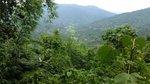
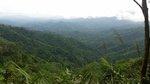
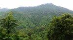
But I did manage one photo, from a viewpoint on this road. Wow, super Talay Hmork at about 08:40.

Then, it was down through Bahn Kok and the 1268, 1239 to Nam Pat, for lunch.
Across to Tha Pla and up 1163 & 1341. More quiet roads and a new reservoir being constructed on the west side of that road and west of the Sirikit dam.

Then looking for the dirt road over to Phrae. Found this, but... no way.... too steep and slippery..


........ more later...................
[GPX=125029;10]GPX Viewer[/GPX]
And admit that the highways around you have grown
And accept it that soon you won't ride on your own
Cause the dirt roads are rapidly fadin...... etc etc...
Not strictly true. But it seems many of the old dirt roads are indeed getting paved. But new dirt roads appearing for theose intrepid enough to find them.
First, I was at Sakoen, just off the good old 1148. The reservoir there was overflowing, as the Mae Nam Ngin.
A little further along, where the Mae Nam Yot crosses the 1148, at Bahn Pa Lak, I went up north and a recently paved little road.
To Bahn Pang San.
Then found a dirt road that is still a dirt road, heading east. Turning right here......
lovely little detour..,...
country scenes....
a technical section down, but not too steep.
The dirt road pops out at Bahn Bannasophit on 1279. This road goes up north to the Laos border crossing.
GPS track;
Track_Loop north 1148.gpx
Riding further on east and south, I finally ended up in Wiang Sa, south of Nan city, for the night. An old style Thai town on the Nan river, that appears to be a dragon boat racing centre. But could not find any bars or restaurants, so ended up eating dinner at stalls in the temple.
Next day, headed out to an old favourite; the 1243 eastern border road from Bahn Sali to 1123. Marked on my map as dirt road, but recently tarmac'd. I'd been here about a year ago, but now the tarmac was starting to break up in places, as it was laid pretty thin (no photos, camera battery flat)...
It used to look like this in 2014;
It is a really quiet remote area. No-one around this time in 2018, either.
But I did manage one photo, from a viewpoint on this road. Wow, super Talay Hmork at about 08:40.
Then, it was down through Bahn Kok and the 1268, 1239 to Nam Pat, for lunch.
Across to Tha Pla and up 1163 & 1341. More quiet roads and a new reservoir being constructed on the west side of that road and west of the Sirikit dam.
Then looking for the dirt road over to Phrae. Found this, but... no way.... too steep and slippery..
........ more later...................
[GPX=125029;10]GPX Viewer[/GPX]
Attachments
-
Track_Loop north 1148.gpx105.7 KB · Views: 849
-
 2018-09-14 11.20.55.jpg113.9 KB · Views: 397
 -
 2018-09-12 15.38.52.jpg151 KB · Views: 413
 -
 2018-09-12 15.41.38.jpg134.8 KB · Views: 387
 -
 2018-09-12 15.52.58.jpg83 KB · Views: 413
 -
 2018-09-12 15.53.27.jpg141.3 KB · Views: 434
 -
 2018-09-12 16.03.20.jpg188.6 KB · Views: 411
 -
 2018-09-12 16.04.58.jpg163.7 KB · Views: 409
 -
 2018-09-12 16.15.57.jpg111.6 KB · Views: 416
 -
 2018-09-12 16.17.12.jpg109.8 KB · Views: 413
 -
 2018-09-12 16.26.41.jpg141.1 KB · Views: 381
 -
 2018-09-12 16.26.46.jpg129 KB · Views: 388
 -
 2018-09-12 16.42.32.jpg161 KB · Views: 391
 -
 2018-09-12 16.54.54.jpg148 KB · Views: 388
